UCI Podcast: Oceans Melting Greenland mission ends
UCI, NASA scientists studied the role of warming sea water on the island’s land ice
The six-year, NASA-funded Oceans Melting Greenland – OMG – mission concluded at the end of 2021. OMG Deputy Principal Investigator Eric Rignot, UCI professor of Earth system science, provided guidance to teams as they used aircraft, small boats and an array of instruments to study the impact of warming ocean water on Greenland’s land ice. In this episode of the UCI Podcast, Rignot talks about the key findings of the project and how the information will help scientists make better projections about the future of polar ice under a changing climate.
To get the latest episodes of the UCI Podcast delivered automatically, subscribe at:
Apple Podcasts – Google Podcasts – Stitcher – Spotify
Transcript
From the university of California, Irvine, this is the UCI podcast. I’m Brian Bell. UCI is a leading institution for polar ice research. Glaciologists in the Department of Earth System Science have perfected techniques using satellite remote sensing technologies and an array of instruments to measure ice thickness the contours of the ground beneath ice sheets and the temperature of seawater that lurks beneath the front of glaciers that are flowing into the ocean.
Through this work, UCI scientists and their collaborators from around the world have been able to develop a much more accurate picture of the dynamics driving the rapid collapse of polar ice sheets. And with that information they can now make more precise predictions about the effects of climate change induced sea level rise on coastal communities around the world.
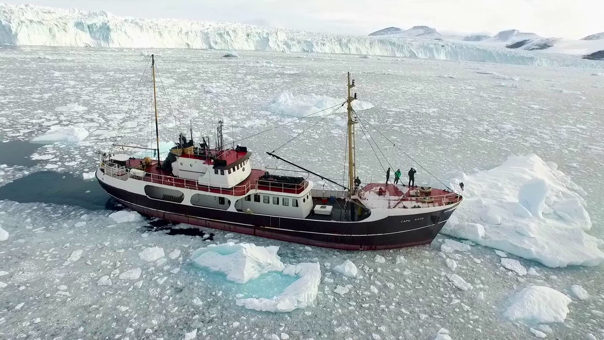
One of the leading figures in the cryosphere studies community is Eric Rignot, UCI professor and former chair of the Earth System Science department. He recently completed a six-year mission, funded by NASA, called Oceans Melting Greenland or OMG. For this project, Rignot and his colleagues at UCI and NASA’s Jet Propulsion Laboratory took to boats and small aircraft to conduct a thorough survey of the coastal regions of the world’s largest island.
In this episode of the UCI podcast includes a discussion with Professor Rignot about OMG and the impact of climate change on polar ice. That discussion is up next.
Professor Eric Rignot, welcome to the UCI Podcast.
Thank you.
Today, we’re going to talk about the project that you had going with NASA JPL for six years, I believe, Oceans Melting Greenland, and, it has just come to a conclusion at the end of this past year. Tell us a little bit about this, this project that you had and what you learned and how you did it.
Yes. So that’s the OMG project, right? Funded by NASA. It’s a sub-orbital mission, so it was operated mostly with airplanes, but also included ships. And the goal of that project was to study how much of Greeland’s ice is melted as a result of a warmer ocean. You know, what is the role of the ocean in the melting of land ice in Greenland? That’s kind of an open question. So the main goal of this mission was to go get the answers in Greenland using a suite of remote sensing tools and in situe measurements. This project was planned to last five years. It was actually extended to another year because things worked so well, so smoothly. And we got excited by the results we got in the first five years. And, I think we very satisfied overall that we accomplished pretty much all the objectives that we wanted to achieve.
Would you say that you learned something about the ice sheets and Greenland that you did not expect? Did you get any big surprises while you were there?
Well, so one of the beauties of this project was not to focus on a couple of places in Greenland, but actually look everywhere in Greenland, all around Greenland, not leave a single spot unsurveyed. That’s always really important when you look at a part of the Earth of system to make sure that your findings or your opinion are not based on the fact that you look at a little area, but the glacier next door is doing something different. So I think, you know, at the end of the day, I would not, I would not dwell in too long details that we, we did find that the ocean plays a major role in evolution of these glaciers. This was sort of accumulating in the paper with my PhD student, Mike Wood, published in Science Advances, summarizing what we found about the largest 200 glaciers in Greenland, that they responded to warming of the ocean waters.
And that’s controlling in the large part, what the glaciers are doing in Greenland today. And in the large out the overall melting of land ice in Greenland. The other component is the one that we most familiar with, you know, in the warmer climate, the snow and ice are melting from above generating a lot of melt water. And we know that very well. The ocean part is a bit more challenging because that ocean heat is not found at the surface. It’s several hundred meters below the surface. We did not know how deep these fjords were and whether they hosted warm water or not. We really needed to go there and find out.
And so you used instruments to measure the temperature of the water deep down as well.
Yeah, so they were a number, a suite of instruments that we deployed. One major one was actually to launch temperature and salinity probes, robotic devices in the ocean all around Greenland, and doing that in as many places as we could. And, repeat that every year. So that could be used to document the presence or not of warm water in some of these fjords. And, and for some of them, these robotic devices were taking one measurements and was in the later part of a mission. We launched robotic devices that can survive and do this yo-yo in the ocean waters and transmit back data to the satellite and continue their work while we’re gone for months.
We can, so you just kind of plant them there and then go away?
Yeah, we plant them there. You have to strategize a little bit because they are carried around by the current. So you have to strategize, you know, how you make them surface and go down and things like that. But then they are launched in an environment that’s full of sea ice and icebergs. So it’s not necessarily straightforward for them to survive a long time. But we’ve had great success with them, and we’ve been able pretty much to document whether is warm water around Greenland is warmer or not. And by repeating that over time, over six years, we’ve been able also to document changes from year to year…
Yeah, I was just going to ask that. Did you see a difference from year one to, until year six?
Yeah. And we, we saw variability. In one year you could find that a bay was really cold that year. You might ask yourself, well, what’s going on here? Well, suddenly it got cold and it lasted a couple of years and then the warm water came back. So all that dynamic is is interesting because we see the glaciers respond almost real time to that. They are cold one year and some of his glaciers don’t melt as much and slow down their retreat. And then in the warm, they melt more and we see them speeding up. So being able to see that dynamic, not just the static field was, uh, was extremely interesting.
What is the impact of warm water on the underside of these glaciers? How does that work?
So the source of ocean heat in polar regions is depth. It’s not like in regions where we live here, where most of the warm water is at the top, it’s at depth, it’s more saline from the formation of sea ice. It rejects a lot of salt and makes these warm water stable at depth. And so it’s present at the root of the glaciers. And it can melt the glacier is very fast, especially since that it’s that depth, the freezing point of sea water is also changing with depth. So it’s easier to melt deep ice than it is at the surface. And the rates of melt of the ice from the ocean are 10 to 100 times larger than what’s happening at the surface. So in a way you could, you could say that melting of his glaciers is from below more than from above from this warm water,
Your work involves a lot of measuring the surface of the ground around the island of Greenland. Is that right?
Well the pitch and angle of the ground as it meets the ocean and where the grounding line of the glaciers is, and, and it, whether that’s pro-grade or retrograde slopes and all that sort of stuff.
Yeah. So you’re right. We, we are very interested in the geometry of the bed beneath the glaciers, because that controls the rate of retreat or stability of the glaciers. That’s an aspect that’s been well addressed by NASA’s Operation IceBridge which started about six years prior to OMG with OMG or whether we’ve been able to refine a lot of that, because we got some really high-precision data about the depth of the bed in front of the glaciers, instead of measuring it with radar through the ice, we measured it with acoustic sonar in front of the glaciers. So under the ice, we know what the bed is within 10, 20 meters in the ocean, we measure it within a meter. We can even do better than that. So it’s super precise. It help us refine what we thought we knew with IceBridge to say things like this glacier is standing on a ridge, or the glacier is going down a steep slope. This glacier is trying to climb up a steep slope. In almost every area where we have been able to do this mapping, it’s essential to understand what the glacier is doing. If you don’t have this information, you can just throw your hands in the air and say, I don’t know what’s going on.
But with that information, you’re able to make a better prediction about what’s going to happen in the future.
We’re able to explain the glacier evolution of the past 40 years. So that’s, that’s a big deal. The only places where we can’t do that is actually where we didn’t get the data, so that shows that we really need to measure these glaciers, but not only we need to measure the bed beneath the ice, we need to measure the sea floor depth in front of the glaciers, because that sea floor controls how much of the ocean heat can come into contact with the glaciers. In some fjords, you have a continuous deep trough that lets the warm water reach the glacier very easily. In others, you can have a ridge in the middle and that ridge is going to block the bottom water, the warmer water and suddenly, the glacier is actually protected from the warm water and the change in the presence of warm water around Greenland, triggered by climate warming, because all of this is related to changing atmospheric circulation around Greenland.
And how much of these warm waters come in contact with the glaciers? It’s, uh, it’s not that the warm waters were never there before. They’ve always been there, but the winds are pushing more of them, uh, in contact with the glaciers. So knowing that geometry of the fjord also is, well, that was exciting to do because you come into these fjords, and you have no idea how deep they are. The maps are way off. And, and then you discover are the exact topography of these fjords, and then you realize, hey, now we understand why this glacier did that and what this one did not, they are next door in the same climate regime, one retreated a lot, and the other didn’t do anything. Uh, it turns out that the other is standing in a shallower fjord. With some of them, they retreated into higher position of, of the ground. Uh, if you look at the surface, when you’re on the boat, you don’t see that you have to peer down in the water and see that the sea floor is rising here. And suddenly the glacier is protected from the warm water.
What are some of the major glaciers that you’ve really kind of had firsthand experience looking at, exploring in Greenland? I know some of the names from the press releases we’ve done over the years, but what are, what are some of the ones that really stand out to you as examples of, wow, this, this is a major sheet of ice that’s really moving fast here.
Well, so there’s, there’s lots of, uh, important glaciers in Greenland, but the one that people are most familiar with is the Jakobshavn Issbrae on the central west coast, because that’s the biggest one, it’s a big tourist attraction. Uh, it turns out also that, uh, it has, it has been a little bit sometimes at odds with the other glaciers. It has a dynamic of its own. So I was a little bit more interested in some of the glaciers that we did not know very well, especially in Northwest Greenland where the prior mapping was, was very poor. OMG and IceBridge turned out of a completely, uh, it was the least well known sector of Greenland and now it’s probably the most well known sector of Greenland. These glaciers play a major role in evolution of the ice sheet. I cannot name you one. There’s like 30 of them.
And, uh, they, they all deeply rooted below sea level and, and they all been retreating quite rapidly. It’s also a part of Greenland that has probably been more affected by climate warming because the ocean was typically a little bit colder in this area. Most of the heat is in the Southeast, not in the Northwest, but with the changes in wind and circulation, suddenly more warm water, went into Baffin Bay and melt these glaciers. So we, we saw more spectacular changes in these places that used to be cold and got warmer than the places that were warm and got a little bit warmer. Right.
I see. So now that oceans melting Greenland, OMG, is concluded, is that the end of your time in Greenland or you going back?
No, it’s not the end of my time. So, you know, we spend a lot of time mapping the bathymetry. That was a big success of this mission is I think we, we sort of map the sea floor in front of all the major glaciers in Greenland. And honestly, when we started this project, I didn’t think we could do that. I didn’t think we, I did enough funding and enough time to do that, but, uh, somehow the mapping worked super efficiently. So we spent the last few years focusing on the hard-to-get places, places where the boat can even cannot even go because there’s ice all the time. So we have to go with, uh, robotic devices. We have to go with helicopters. It’s more time consuming, but these glaciers are important too. So there’s still a few of those, but we’re trying to get to, and there are also glaciers in the north that don’t have a clean calving face in the ocean. They start floating in the ocean before they break up and to measure the sea floor underneath these glaciers is much more challenging. You have a several hundred meters of glacier ice floating. You have to go underneath that. Uh, we can’t go with a boat. We can’t go with a submarine.
You can’t do a submarine underneath.
No, you cannot swim. Uh, so the, the idea is to drill a hole and you can get one point measurement or to send robotic devices. So a lot of my sort of post-OMG activity now is to invest a lot more on robotic technology, which exists from all the research done in the open ocean and use that technology to explore these areas that we have not yet been able to map.
Now, you and your colleagues have a recent paper in Nature Geosciences about the Smith, Pope and Kohler glaciers in West Antarctica. Yeah. You’ve, you’ve done a lot of work in Antarctica as well. So tell me a little bit about how that work relates to what you done also in Greenland.
Yeah, that’s a good question. It’s, it’s completely related. And some of the glaciers in north Greenland are a perfect analog to the glaciers in West Antarctica. In a way they are a bit more accessible. Uh, you know, we can take a boat in Greenland. We fly to Greenland, take a, then go survey it. In the Antarctic, it’s a lot more complicated to do that sort of thing. And even if you have the boat and the funding, sometimes you can’t get to the glacier, there’s sea ice, weather, the area is seven times bigger than Greenland. The weather is more challenging, but the physical process is that we learn about in Greenland are the same operating in West Antarctica. So everything we learn about the way ice melts in the ocean, the way ocean heat circulates around Greenland and reaches the glacier is relevant to West Antarctica. One thing I would say that stands out out all of that is that the OMG exercise demonstrate that we need to do something similar in the Antarctic. If we don’t have this extensive mapping and collect all these critical observations, we will not be able to, one, explain what we are seeing today. And, two, make reasonable projection of what these glaciers are gonna do tomorrow.
Well, want to thank you very much for the time you’ve spent with me today explaining your research, and good luck to you this year.
Thank you, Brian.
You can learn more about Professor Eric Rignot’s research by visiting the Department of Earth System Science website at www.ess.uci.edu. Also, there are dozens of press releases, feature stories, and other materials about glacier research in the UCI newsroom at news.uci.edu.
The UCI podcast is a production of strategic communications and public affairs at the University of California, Irvine. I’m Brian Bell. Thank you for listening.