UCI-led study helps explain Greenland glaciers’ varied vulnerability to melting
More accurate maps of bed topography reveal physical processes controlling retreat
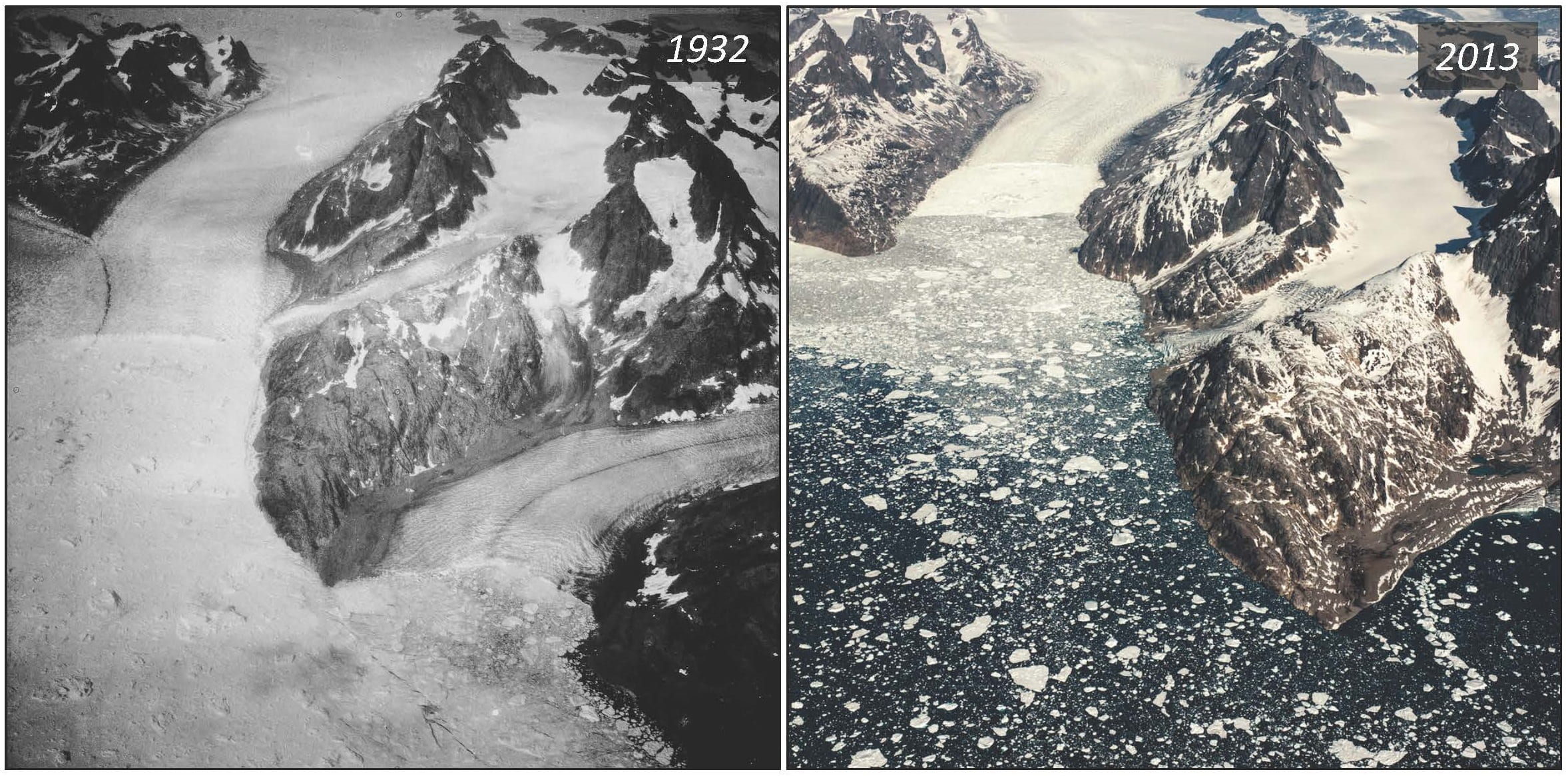
Irvine, Calif., March 14, 2018 — Using data from NASA missions observing Earth, researchers at the University of California, Irvine have created new maps of the bed topography beneath a score of glaciers in southeast Greenland, thereby gaining a much better understanding of why some are undergoing rapid retreat and others are relatively stable.
“The undersides of glaciers in deeper valleys are exposed to warm, salty Atlantic water, while the others are perched on sills, protected from direct exposure to warmer ocean water,” said Romain Millan, lead author of the study, available online in the American Geophysical Union journal Geophysical Research Letters. “We have been able to demonstrate unequivocally that glacier retreat in southeast Greenland is controlled by the topography of the bedrock under the ice and by ocean temperature.”
Millan, a UCI graduate student researcher in Earth system science, and his colleagues analyzed 20 major outlet glaciers in southeast Greenland using high-resolution airborne gravity measurements and ice thickness data from NASA’s Operation IceBridge mission; bathymetry information from NASA’s Oceans Melting Greenland project; and results from the BedMachine version 3 computer model, developed at UCI.

They found glacial fjords hundreds of meters deeper than previously estimated; the full extent of the marine-based portions of the glaciers; deep troughs enabling Atlantic Ocean water to reach the glacier fronts and melt them from below; and few shallow sills that limit contact with this warmer water.
“It’s important to understand the physical processes controlling the retreat in order to improve projections of sea level rise from this region in a warming climate,” Millan said. “Until recently, we had little information on ocean temperature and water depth in these fjords to quantify these processes, so the interpretation of glacier evolution on a case-by-case basis was difficult.”
Co-author Eric Rignot, UCI professor of Earth system science, added, “Now that the picture is clear, the role of the ocean in glacier evolution is overwhelming.”
Rignot, who has led dozens of research expeditions to Earth’s polar regions, said that southeast Greenland – with its fast-moving glaciers, deep fjords and harsh climate conditions – poses significant challenges to researchers.
“Thanks to the newest NASA missions, such as Oceans Melting Greenland and Operation IceBridge, we have been able to make great advances in understanding the evolution of this very dynamic sector of Greenland and its impact on sea level rise now and in decades to come,” he said.
The study was funded by NASA’s Cryospheric Science Program.
About the University of California, Irvine: Founded in 1965, UCI is the youngest member of the prestigious Association of American Universities. The campus has produced three Nobel laureates and is known for its academic achievement, premier research, innovation and anteater mascot. Led by Chancellor Howard Gillman, UCI has more than 30,000 students and offers 192 degree programs. It’s located in one of the world’s safest and most economically vibrant communities and is Orange County’s second-largest employer, contributing $5 billion annually to the local economy. For more on UCI, visit www.uci.edu.
Media access: Radio programs/stations may, for a fee, use an on-campus ISDN line to interview UCI faculty and experts, subject to availability and university approval. For more UCI news, visit wp.communications.uci.edu. Additional resources for journalists may be found at communications.uci.edu/for-journalists.